Skip to content
BetaNYC
  • About
    • About BetaNYC
    • Our History
    • Our Team
    • Alumni Network
    • Supporters
    • Job Openings
    • Code of Conduct & Anti-harassment Policy
  • Our Work
    • Civic Innovation Fellowship
    • Civic Innovation Lab
    • Apprenticeship Programs
    • Public Programs
      • Open Data Week
      • School of Data
      • Open Data Journeys
      • Open Data Ambassadors
      • BetaBagels
  • Resources
    • Research and Data Assistance Requests (RADAR)
    • Mapping For Equity (M4E)
    • Featured Tools
      • Boundaries Map
      • Urban Heat Portal
      • Floodgen
      • School Budgets Dashboard
      • D33 Tree Stewardship Map
      • Topographic Address Assignment Database
      • NYC Batch Geocoder
      • Scout
    • Publications
    • Testimony
    • Teaching Materials / Classes
  • Events
    • Event Calendar
    • Events News
  • News
  • Get Involved
    • Join Our Community
    • Upcoming Events
    • Newsletter
Newsletter
Donate

Ridership Data

Description
Used open source research to quantify ridership data along the 2, 3 line.

Data sources: 
– Open Data Platform
– MTA Ridership Data

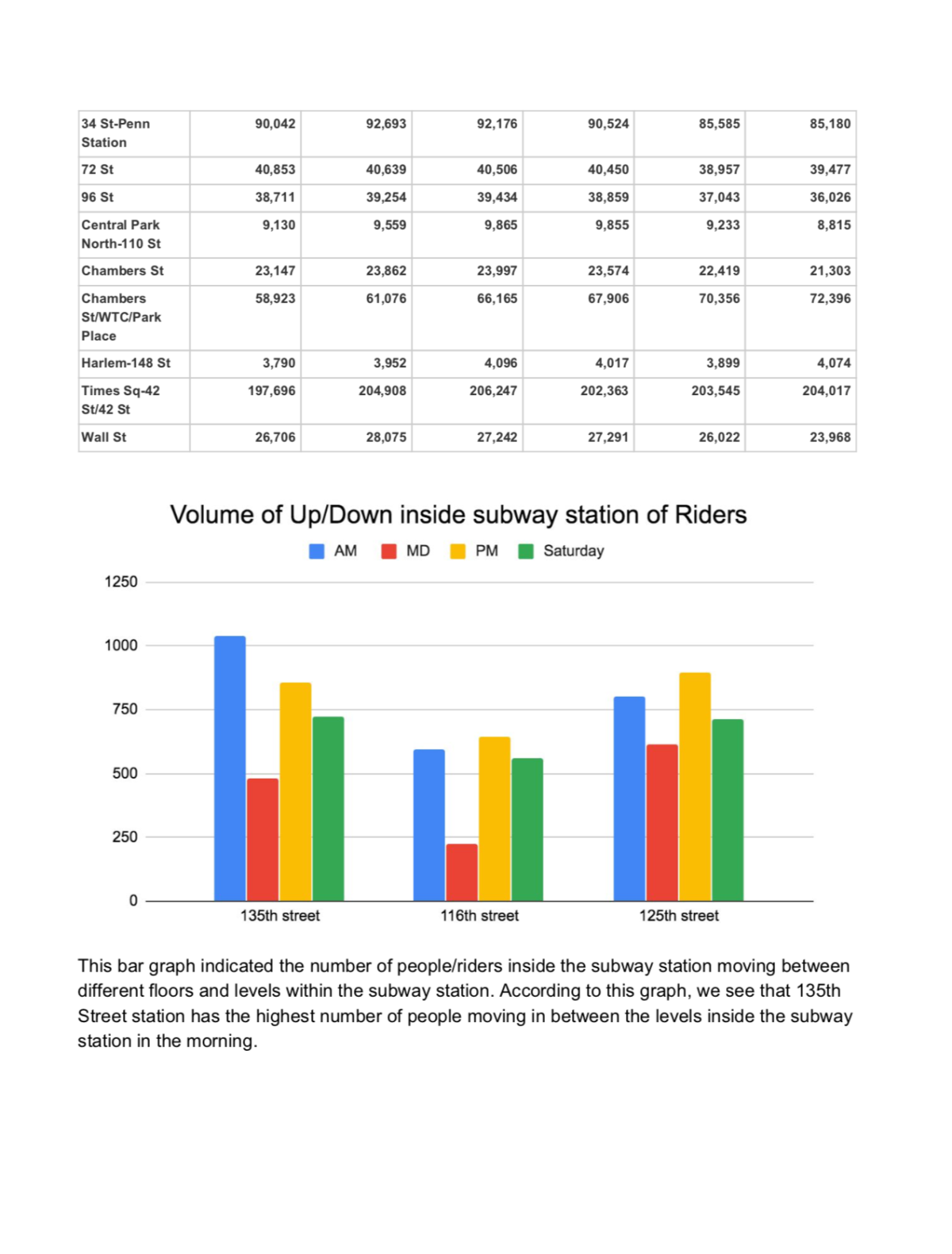
Uses: For the community and the Manhattan Borough President’s Office to gain more information about the new development proposed for 135th and Lenox.

Impact:  Informed ULURP (Uniform Land Use Review Process) for Lenox Terrace, where a developer planned to build housing for an additional 2,000 residents, and our data also provided additional information to the Tenants’ Association there to compare with the data provided to them in the Environmental Impact Statement.

Level: 3

Hours Worked: 4

Number of Personnel who contributed: 2

About Us

BetaNYC is a 501(c)(3) non-profit organization via The Fund for the City of New York’s partner project program.


All original content is Copyright, Creative Commons 4.0 Attribution-ShareAlike.

  • LinkedIn
  • YouTube
  • >
  • Mastodon
  • Bluesky